
Source: NOAA
Yesterday, the National Oceanic and Atmospheric Administration (NOAA) issued its annual prediction of the size of the Gulf of Mexico hypoxic or “dead” zone and it is expected to be nearly 8,000 square miles (roughly the size of the State of Massachusetts) and could rival the largest one ever, which happened in 2017. This year’s “abnormally high amount of spring rainfall in many parts of the Mississippi River watershed, which led to record high river flows and much larger nutrient loading to the Gulf of Mexico” is a major factor in the huge size of this year’s dead zone.
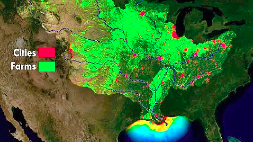
Why This Matters: The dead zone is caused in great measure by current agricultural practices — fertilizers flow off farmlands and into small drainage ditches and streams and eventually make their way into the rivers that flow into the Mississippi River, but also by urban runoff. This type of pollution really adds up — this year 156,000 metric tons of nitrate and 25,300 metric tons of phosphorus flowed into the Gulf of Mexico in May alone. This volume of nitrogen pollution is 18 percent above the long-term average, and phosphorus loads are about 49 percent above the long-term average, according to NOAA’s press release. Once it reaches the Gulf of Mexico, all that nitrogen creates a huge amount of algae that eventually dies, then sinks and decomposes in the water and causing marine life there to “choke” and die or move away from the area. They call it a “dead zone” for a reason. Scientists are hoping to change agricultural practices and shrink it to an annual average of only 2000 square miles, which still seems huge, and we are a long way from achieving this goal.
By The Numbers:
- The largest dead zone in the Gulf of Mexico on record was 8,776 square miles set in 2017; the 5-year average measured 5,770 square miles.
- The U.S. government operates more than 3,000 real-time stream gauges, 50 real-time nitrate sensors, and 35 long-term monitoring sites throughout the Mississippi-Atchafalaya watershed, which drains all rivers and streams in parts or all of 31 states and 2 Canadian provinces into the Gulf of Mexico.
- According to NOAA, this past May’s discharges into the Mississippi and Atchafalaya rivers were approximately 67% above the long-term average between 1980 and 2018.
How Do We Know?
- NOAA will confirm the size of the 2019 Gulf dead zone in early August, a key test of the accuracy of the models on which the forecast is based — this is only the second year NOAA has created the forecast on its own.
- One other caveat — the NOAA forecast assumes typical coastal weather conditions, but the measured dead zone size could change by major wind events, hurricanes and tropical storms which mix ocean waters.
- Ecowatch reported that researchers from Louisiana State University (LSU) also predicted a large dead zone this year according to a statement on Monday predicting this year’s dead zone to be 8,717 square miles, making it nearly the same size as the largest ever.
June 17, 2019 » #Cleanwater, dead zone, Gulf of Mexico, hypoxia, Mississippi River, nitrogen, phosphorus, runoff
